Triangle Hofbrau, Pequannock

Pequannock residents still fondly recall a German restaurant known as the Triangle Hofbrau. In its last incarnation, it stood on Route 23 in Pequannock at the corner of Madison Street. It was an authentically high-class German restaurant, specializing in sauerbraten, roast Long Island Duckling, leg of lamb, reh schnitzel (venison steak), and a variety of seafood.

Triangle Hofbrau’s holiday dinner menu. Literally everything from soup to nuts.

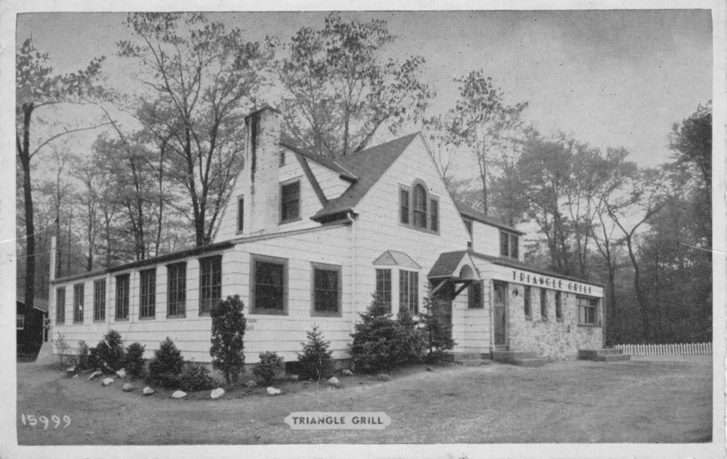
The original Hans’ Triangle Grill, a humble hot dog stand, was opened about 1932 on the Newark-Pompton Turnpike, on a literal triangle of land that intersects Lincoln Park Road. (In later years the location would be home to The Point, Rumsellers, and other establishments. Now, it’s a bank.) It was owned and run by Hans and Hilda Gropp, who had immigrated years before.

In 1933, when NJ began building Route 23, Hans and Hilda purchased land on the southbound side and moved the Triangle Grill there. The grand opening on July 30, 1936 was an immediate success, due in part to the traffic passing by. In those days, the highway’s north- and south-bound lanes were separated by a grass median. Conveniently, an opening in the median permitted north-bound cars to pull right into the parking lot.

At first, the Triangle Grill didn’t have a bar.

Inside, the tap room and dining rooms were finished in knotty pine to resemble an Alpine hunting lodge. A varied selection of choice wines and liquors joined the menu. At some point soon after, the Gropps renamed it the Triangle Hofbrau, and expanded their menu, making it a full-fledged — and authentically German — restaurant.

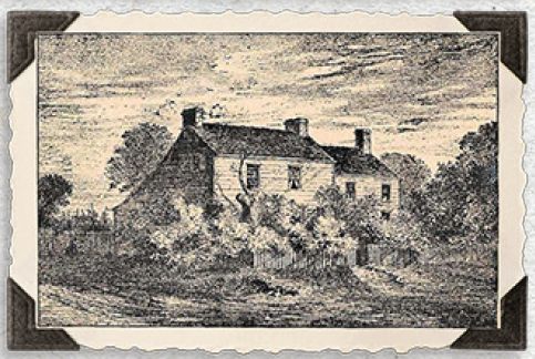
Over the decades, various changes and additions were made. I believe this was how it looked in the 1930s. The original house (with living quarters upstairs) is still recognizable. At the far right was the original walk-up window for hot dogs and such. The parking lot is unpaved, too.

When the Triangle Grill re-opened on Route 23, there was a walk-up window — you can see the steps at the far right — but an indoor seating area made it obsolete. At some point, the Dutch Colonial roof line was replaced with a standard peaked roof.

The Hofbrau served the area for many decades. The Gropps retired; other owners took over. According to W. Jay Wanczyk, head of the Pequannock Historic District Commission, ownership only changed hands three times in all of its history.

But in late 2007, the Triangle Hofbrau closed its doors for the last time. The place was sold to new owners, and Tiff’s Rivaaz now serves delicious food in its stead.

This is how I remember the Hofbrau; I passed it a zillion times, as I grew up on Madison Street. Compare with the earlier photos.

Several additions were made to the Hofbrau, including the huge dining room at left.

-30-

C.D.V. Romondt, MD

Dr. Charles D. Van Romondt (1847-1926) — typically referred to as “C.D.V. Romondt” — was described as a man “whose reputation is wide-spread”, and as “a leader in all plans which tended toward the elevation of the community with which he has been connected for so many years.”

Dr. Romondt’s residence was on Schelling Terrace, just off the Turnpike, and was razed in 2018.

Born in 1847 in New Brunswick NJ, he attended public school there. He was admitted into the College of Physicians and Surgeons at Columbia University in New York City, and graduated in 1872. He practiced medicine there for a few years before deciding to move to Pompton Plains in 1878. According to Emily Slingerland, quoted in a 1964 newspaper article, Dr. Romondt was the first doctor to live in the township. Before that, those seeking medical treatment needed to travel to Bloomfield.

Besides his medical practice, Romondt served as the township’s health inspector, as well as the medical inspector for the schools there. He also found time to be employed as a medical examiner for several insurance companies.

In 1890 he married Anna Doremus ( 1856–1955 ), who assisted her husband during his long medical practice in Pompton Plains.

The doctor was a member of several civic organizations, including the Junior Order of United American Mechanics. This group met at Paul Revere Hall, which isn’t surprising given the Jr. O. U. A. M. built it. You can view the cornerstone — today, the building is known as the American Legion Hall.

He died in 1926 and is buried at the Reformed Church in Pompton Plains.

“Remember the Maine!”

The intersection of the Paterson-Hamburg Turnpike and Wanaque Avenue, in Pompton Lakes, has featured several noteworthy structures. Here’s one of them.

During the Revolutionary War, a house known as the Yellow Tavern stood close by the intersection where the present-day Federal Square memorial now stands, on a triangle of land. The tavern welcomed visitors on their journeys throughout north NJ, including General George Washington and his officers and men. It was razed about 1890 “to permit the changing [widening] of the roads,” as an old manuscript put it. (The house that replaced the tavern, much later known as the Ramapo Valley House, survived… but that’s another post.)

The Yellow Tavern, from an 18th Century drawing.

A memorial consisting of a cannon (likely Civil War), a stack of cannonballs, and a “liberty pole” topped by an American flag, stood upon the triangle of land at the historic intersection until 1914. On Labor Day of that year, a town memorial was dedicated on the site to honor the men who lost their lives when the U.S.S. Maine exploded in Cuba’s Havana Harbor on February 15, 1898. “Remember the Maine!” became a rallying cry.

This tragedy cost 260 American lives and later led to the Spanish-American War of 1898. This link will bring up a list of the casualties by name and rank, but it doesn’t include their hometowns. (Here’s a lengthy article which outlines how to discover more information about them.)

The site was used as a war memorial for many years before the Maine memorial was erected. Click for full-sized image.

Consisting of a raised round platform and a fieldstone-and-concrete tower, the monument on the triangle — also known as Federal Square — “contains a copper ventilator from the Maine battleship. The ventilator was transported to Pompton Lakes by Harry Hershfield, a Pompton Lakes Mayor who went on to become a state Senator.” As you can see in the photo below, the existing memorial was incorporated into the design, and a chain was draped around the raised platform.

This photo was taken about 1918. Click for full-sized image.
The plaque on the memorial, in honor of the local members of the Council of the Jr. Order of the United American Mechanics. Click for full-sized image.

Since then, many cosmetic changes have been made to the memorial site, which now features nice greenery and a historic marker denoting the site of “Washington’s Headquarters”. The origin of the cannon was forgotten long ago, and the pile of cannonballs disappeared at some point. Two nearby memorial stones honor the dead of World War I, World War II, and the Korean War. A flagpole flies the American flag and, below, a POW/MIA flag in memory of those who served in the Vietnam War.

The Pompton Lakes Liberty Bell was presented to the borough in 1957 by the Pompton Lakes Elks Club. Click for full-sized image.

And so the Maine monument at Federal Square has remained, nearly untouched, although time is taking a toll.


The copper ventilator, unprotected from the elements, has been slowly disappearing over the past century. Click for full-sized image.

Why is this article titled “Remember the Maine!” ? The actual cause of the explosion will likely never be known, but the theory that a Spanish mine in the harbor was the reason she sank (never mind that she was riding at anchor) caught fire with the press:

[P]opular opinion in the U.S., fanned by inflammatory articles printed in the “yellow press” by William Randolph Hearst and Joseph Pulitzer, blamed Spain. The phrase, “Remember the Maine! To hell with Spain!”, became a rallying cry for action, which came with the Spanish–American War later that year. While the sinking of Maine was not a direct cause for action, it served as a catalyst, accelerating the approach to a diplomatic impasse between the U.S. and Spain.

Wikipedia

Later investigations would plausibly suggest that the explosion was more likely caused by a magazine explosion within the vessel, possibly caused by a coal fire.

F.B. Whittle Hardware, Butler & Pompton Lakes NJ

Once upon an era, every town and village had a hardware store. In many instances, it was also the general store, post office, and community center where men would discuss the matters of the day.

F.B. Whittle Hardware building
Whittle Hardware, shortly after closing in 2001

Frank B. Whittle was born in England in 1860, and (presumably with his family) came to America in 1870. He lived in Sussex, where he had a position with the Lawrence Hardware Company. He met and married Harriet Beemer and had a daughter, Edith, in 1886.

Apparently an upstanding citizen, Whittle was at various times Butler’s Borough Clerk, Registrar, and chief of the fire department.

In 1905, the company incorporated, with S.F. Quince and Frank Whittle, “former employees of the firm”, as the incorporators.

According to a trade magazine’s report, “The company is intending to open a branch Hardware and plumbing establishment at Butler, N.J.”

Frank and his family moved to Butler, where he opened the branch store downstairs from the Butler Opera House. A fire in December 1906 destroyed the Opera House and several nearby structures. He was fortunate that a sturdy three-story brick building had been recently finished at 208 Main Street. This became the new home of The Lawrence Hardware Company, which sold plumbing, hardware and heating supplies. He ran this store until 1915, when he moved to Pompton Lakes to open a branch store.

Still interested in local affairs, he was at some point elected mayor.

A “Mayor” badge awarded to Whittle in Pompton Lakes.

In 1921, he bought the store and ran it under his own name.


Whittle remained in Pompton Lakes until 1923 when he sold his business to Adam Jeckel and resigned as mayor. The following year, he moved to Butler and organized (and was president of) the F.B. Whittle Hardware Company. He purchased the Butler store, which operated under his name until the store closed in 2001.

Correspondence with Lamson & Goodnow, a Massachusetts cutlery company.

Whittle Hardware as most of us remember it.
1932 Ad in the Butler Argus

From Scherer’s Inn to the Riverdale Lodge, Riverdale NJ

The history of this place begins with Joseph Slater, who around 1861 bought Ford’s Mill, located on Paterson-Hamburg Turnpike near the intersection of Newark-Pompton Turnpike. That mill became Slater’s Mill, which processed felt for hats.  A relative (brother?) named Otis built a house across the intersection on the southeast corner.

I don’t know the full history of this busy corner, but at some point the house was transformed into a tavern, and later added rooms to let, making it Riverdale’s first (and likely only) hotel.  This very busy place was apparently known as (not necessarily in this order):
  • Old Maple Inn (unconfirmed)
  • Scherer’s Inn (Joseph Scherer, proprietor) – 1920s
  • Riverdale Hotel and Restaurant  – 1930s
  • Old Heidelberg Tavern (Herman & Anna Zerr, proprietors) – 1930s
  • German Inn (unconfirmed)
  • Hunter’s Inn (Bert Lamb, proprietor) – early 1940s
  • Bert Lamb’s Riverdale Lodge (Bert Lamb, proprietor) – 1942-1946
    (Lamb sold it in 1946 but it was still in operation in 1948)

I don’t know the full history of this busy corner, but at some point in the 1920s the house was purchased by a German immigrant named Joseph Scherer. He might have turned the place into a restaurant/guest house (or perhaps it already was) and named  it” Scherer’s Inn”. Scherer and his family — a wife, four (or five) children, and some others — lived there as well as ran it.

Scherer's Inn, Riverdale (1929)
Scherer’s Inn, Riverdale (1929)
At some point in the 1930s, it became the Old Heidelberg Tavern and was operated by Herman Zerr and his wife, and likely his two daughters as well. Apparently they kept it up until Herman’s death in 1937.
Old Heidelberg Tavern, Riverdale
There was probably another owner and another name, maybe more than one, before Bert Lamb bought it. Lamb, a New York entrepreneur, ran the place as a diner/tavern in the early 1940s which he called the Hunter’s Inn. Evidently he upgraded it to “Bert N. Lamb’s Riverdale Lodge” in 1942, and held a glorious grand opening on May 20, 1942 from 2 p.m. “until closing”. Guests enjoyed a buffet lunch and barbecue to the sounds of Harold G. Hoffman’s band.
Riverdale Lodge grand opening invitation (1942)

A 1946 newspaper article notes that Lamb sold it to Joseph Sudyka of Bloomfield for $40,000. An article from 1948 revealed that it was still a going concern.

It’s worth noting the telephone number, from Scherer (at least) through Lamb, never changed: POmpton Lakes 540.

A classified ad offered the place for sale in 1963, noting the property contained “152 foot road frontage on Paterson-Hamburg Turnpike” and was “357 feet deep”.

At some point — perhaps the 1960s — the decision was made to widen that portion of Hamburg Turnpike. That spelled the end for the venerable old house. Today, the site is occupied by a gas station.

-30-

Businesses on Main Street, Butler NJ, early 1900s

If you could somehow pluck a citizen of Butler, NJ, off Main Street a century (or more) ago, and plop him down in the same place today, he’d immediately recognize his surroundings. Butler is one of those towns which hasn’t changed substantially over that time. (Compare with any photo of, say, downtown Manhattan, where very little remains from the past.)

Not only is this really cool to a history buff, it also makes it easier to pair the businesses of then to the businesses of now. Here’s what I know:

Judging by the car, this is early 1900s.

The large gold sign on the store reads “Goldstein Bros” … currently there is no third & fourth story, due to a fire. This is the large building formerly occupied by Levine Bros clothiers.

Main Street, Butler NJ, early 20th Century
Main Street, Business Section, Butler NJ in the early 1900s. Click for full-sized version.

The store next door, closer to the photographer, has no large sign, but you can read “Soda” at the bottom of the window. This is the building currently occupied by Butler News & Candy Shop (150 Main St) — largely unmodified since this postcard!

The building closest to us is at 144 Main Street, currently occupied by Alvino’s Barber Shop.

The building to the left of Goldstein’s would then be the WCTU building (156-158 Main St), currently occupied by Mizuki restaurant. It appears the roof was rebuilt and is, today, higher than in this photo. Indeed, it appears that the WCTU sign is there, hung above the second-story porch.

The next building beyond, a house, at 160 Main Street is currently Vanderhoof & Sons Custom Heating.

And note you can see the RR station at left, down the block.

A Church is Reborn

October 24, 1937 was a bleak day for Pequannock Township. In a matter of hours, the First Dutch Reformed Church, first constructed in 1771, was entirely gutted by an early-morning fire. It took the combined efforts of 70 firemen from six other communities, in addition to Pequannock, to bring it under control.

There’s some fascinating video footage of the fire here, filmed by resident and local historian Carl Edwards. If you watch closely, the camera sometimes pans around to show the surrounding area.


It took the congregation less than a year and a half to completely rebuild the church from “ashes to splendor.” There’s video of the rebuilding process at this link, again courtesy of Mr. Edwards. The church is still in use today, known as the First Reformed Church of Pompton Plains.

(Click on the images for a full-sized version.)

Jones store robbed!

No, not that Jones store. This happened in August, 1881:

Newspaper article about the 1881 robbery of William Jones’ store

Exchanging Shots with Burglars

Paterson, Aug. 10. – Word has just been received here of an encounter with the Storms gang of burglars at Pompton Plains on Sunday night. …

A year ago they robbed the store of Mr. William Jones, at Pompton Plains. On Sunday night last, sometime between midnight and 2 A.M., Mr. Jones heard a noise in the house. Going into the basement, he heard footsteps in the store. He immediately went up stairs, got his revolver, and went outside, where he found that a window shutter had been removed.

Peering in, he could see a man rummaging among the goods, and immediately fired at him. The burglar gave a shriek of pain. The light inside was extinguished and four shots were fired at Mr. Jones and his wife, who had followed him.

As they were standing in the bright moonlight, they retreated, and the robbers decamped. Mr. Jones recognized the man he shot as Jake Storms. He is thought to be wounded.

(Click on the image for a full-sized version.)

No idea where William Jones’ store was, or for that matter, who he was. I asked Rob Jones, but he didn’t recognize the name as part of his family tree. His grandfather took over an existing hardware store in April 1929, but that’s all I know, except that at one point, the place was a general store (and likely a post office) run by the Berry family.

I haven’t had any luck, so far, tracing the elusive Jake Storms further in history. Did he survive? Did his gang return to burgle again? Wouldn’t I like to know.


The Route 23/46 Interchange, Wayne NJ (1964)

Today, the area where Route 23, Route 46, and Interstate 80 meet is a veritable ‘spaghetti bowl’ of highways, ramps, and overpasses. Decades ago, though, there was just Newark-Pompton Turnpike (Route 23) and Route 6 (today’s Route 46, but it’s been renumbered a lot).

In the 1960s, before I-80 came through, this was what the interchange looked like. This photo shows us looking east. Route 23 is at left and at right. Some remember there being traffic lights on the traffic circle.

Aerial view, Route 23 & 46 (1964)

(Click on the image to view it full size.)

If you look at the buildings near bottom right — just to the left of the ad “winter supplies” — you’ll see where Orange Trailer was. This trailer-rental company was owned & operated by the Heslin family of Pequannock. (If you have similar memories, let me know in the comments.)


More about the ‘Ghost Bridge’ of Oak Ridge Reservoir

(This is a continuation of the original post that you can find here.)

I found this line drawing in an 1891 journal titled Engineering Record, in an article titled CONSTRUCTION OF THE EAST JERSEY WATER COMPANY’S AQUEDUCT AND RESERVOIRS. It’s a lengthy piece about the massive undertaking of building five reservoirs in north Jersey for the benefit of Newark. (Another of my interests. You may yawn, if you like.)

So this line drawing is described thus: “Figure 3 is a view of the three-arch bridge carrying the new highway across an arm of the Oak Ridge reservoir. At full stages of the water these arches will be completely submerged.”  

Which, of course, they are, as per this blog post. If you’re lucky to be there during a drought, you too can see it… even walk on it, if you dare.

Ghost Bridge illustration (1891)

The “new highway” wasn’t all that new; it was the Paterson-Hamburg Turnpike. At the time the Oak Ridge reservoir was under construction, the roadway ran along the shore of the river. But clearly, the roadway would have to be moved to higher ground, which it was, reportedly around 1927.

Looking north on the east shore of the Oak Ridge Reservoir, late 1890s. On the right is the railroad. (Click image for full-sized view.)

In this photo we see the original route of the Paterson-Hamburg Turnpike (Route 8) which followed the eastern shore of the reservoir. The ridge supporting the railroad is visible on the right, well above the roadway.

And if you examine the photo closely (or click on it to open it up full size), at lower left is the old bridge that led to the village of Oak Ridge.

Where the original roadway was not far above the water line, today’s highway is elevated several yards higher — almost level with those railroad tracks — to prevent any flooding issues. The highway was also straightened, such that it proceeds nearly north (to the left) of the roadway here, and very close to the bridge. Today, if you park on Route 23 South near the bridge, you look down on it, over a very steep incline, and from a much closer vantage than shown here.