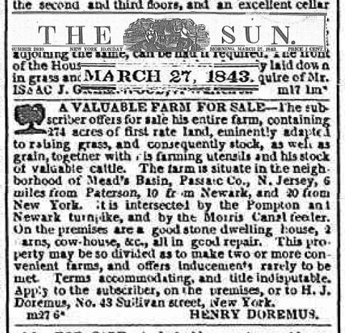
In 1843, Henry Doremus of Wayne offered “a valuable farm for sale.” It contained 274 acres of first rate land.
In real estate, location is everything: “The farm is situate in the neighborhood of Mead’s Basin, Passaic Co., N. Jersey, 6 miles from Paterson, 10 from Newark, and 20 from New York. It is intersected by the Pompton and Newark turnpike, and by the Morris Canal feeder.”
Ad in the NY Sun for the Henry Doremus farm.
Mead’s Basin was in Mountain View, and the “basin” was a large pond where canal boats traveling on the Morris Canal could tie up for the night to shop or to dine. The basin was the parking lot by (the now closed) Mother’s, formerly Gabriel’s.
The offer was for lock, stock and barrel: “On the premises are a good stone dwelling house, 2 barns, cow-house, etc., all in good repair.” We can only wonder whether that house still stands, given that so much history has given way to strip malls, road widenings, and housing developments.
What became of Henry Doremus? The family was quite well known in the region, and a search reveals dozen of potential matches by that name. A Henry Doremus served as the postmaster at Mead’s Basin in the early days of the Morris Canal, but who knows?
Little remains of it today, but the “Pompton feeder” was an integral part of the Morris Canal system’s eternal need for water. The feeder was used to supply additional water to the Morris Canal by channeling water from the Pompton River. The feeder was, in fact, a navigable mini-canal that ran nearly five miles south from Schuyler’s Basin, at the river, to Mead’s Basin (known as Mountain View today). There was also a lock that afforded access to canal boats to the Ramapo River to head north.
The entire route looked like this. Click on it to view it full size.
Map of the Pompton feeder canal (credit: Joe Macasek)
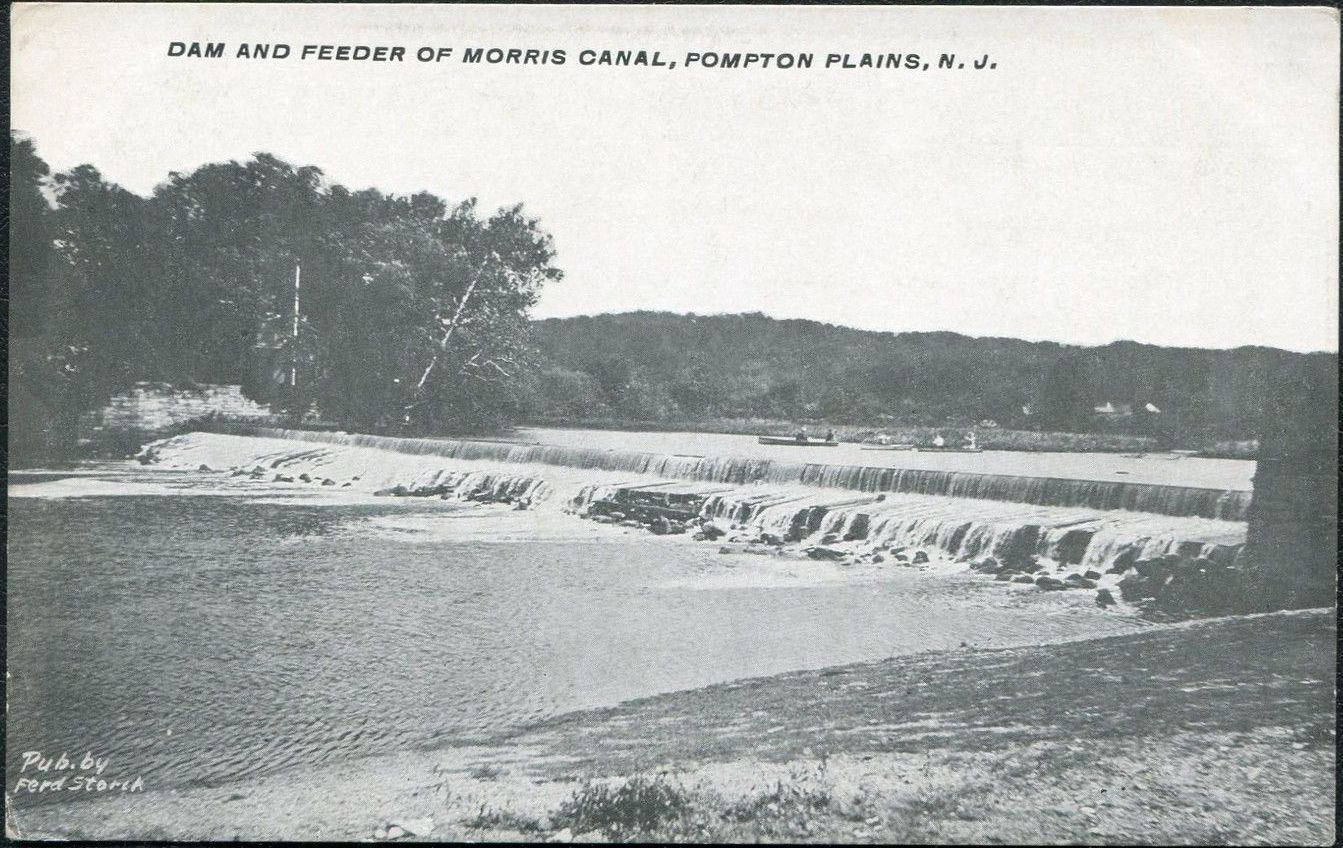
A wide, low dam was built on the Pompton River in Pompton Plains, NJ in 1837, six years after the Morris Canal was completed. This supplied a feeder lock which could, at the lock tender’s discretion, release water into the feeder canal.
Photo taken circa 1906 shows the wide, low feeder dam on the Pompton River.
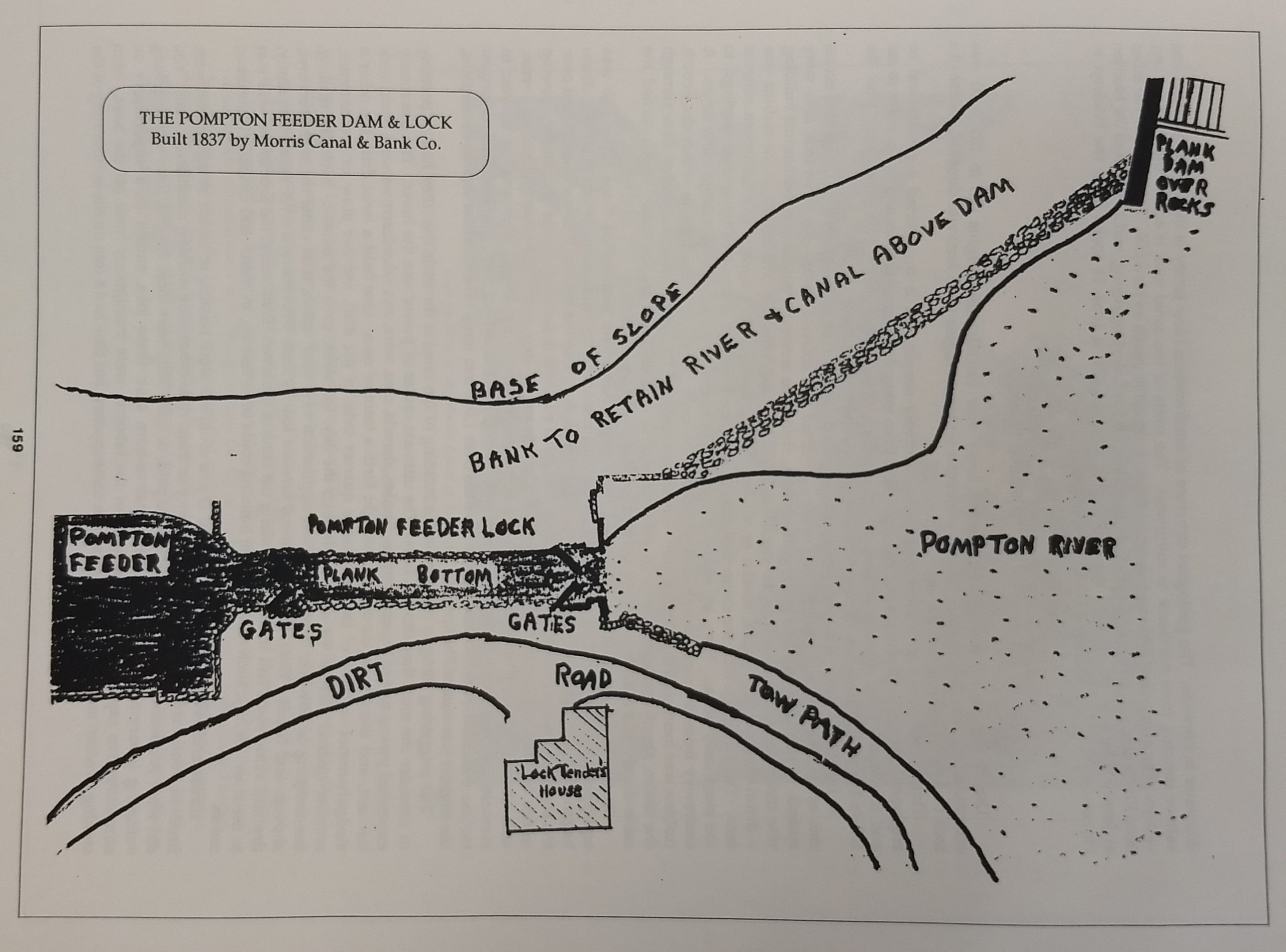
This diagram shows the setup: the river supplies water to the feeder canal via a lock. A lock tender lived in a house on site to release water as needed.
From “History of Pequannock Township” (1990) by George Parr, p. 159
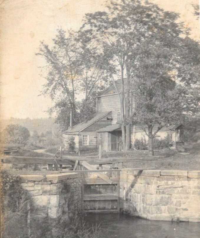
This early 20th Century photo shows the lock tender’s house and the lock.
The lock tender was always on call.
The Pompton feeder canal primarily served as an artery of the Morris Canal. The feeder lock — which was just upstream of the feeder dam — not only helped to maintain the feeder canal’s water level. It also admitted canal boats which traveled up from Mead’s Basin (Mountain View), through the lock, and into the Ramapo River, carrying coal and other supplies north to the Pompton Furnace area in Pompton Lakes. The boats would carry iron (and on occasion other) products back down to Mead’s Basin.
According to historian Ed Lenik, “The Pompton Feeder was a significant waterway: it provided water from Greenwood Lake to the Morris Canal’s eastern division. Pig iron, bar iron, wood, and other products were shipped south and coal, building products, food, and other merchandise were shipped north.”
The feeder canal also provided splendid recreation year ’round — fishing and swimming and canoeing in warm weather, and ice skating in the winter.
Canoeing was a popular pastime on the feeder canal. The bridge in the distance allowed foot and horse traffic to cross the feeder.
The feeder canal more or less paralleled the Pompton River. This photo, taken near the Newark-Pompton Turnpike in Pequannock near the Wayne border, shows the river (left) and the feeder canal side by side. The canal still exists as a muddy ditch. The bridge carries the Newark Watershed pipeline over the river and on to the cities which it serves.
The Morris Canal was successful for about a century before succumbing to the faster and more efficient railroad system. It was decommissioned about 1924, and large sections of it were drained and used for other purposes. Only a small part of the feeder canal itself remains in lower Pequannock; the lock lies in ruins, and the lock tender’s house was razed long ago. What remains is the feeder dam and spillway, which are part of the Morris Canal Greenway initiative, which is “envisioned as a 111-mile continuous pedestrian and bicycle trail connecting six counties in northern New Jersey.” Many segments of the greenway have already been completed, and a trail map is available as a guide to them.